


Subscribe To Sunhusky's Alaska
Monday, May 31, 2010
Saturday, May 29, 2010
Memorial Day Weekend, Lake Lucille
 Reflections on Lake Lucille
 Oh, my gosh, what's a herd of ducklings called?
 Behind the Best Western
 Is it any wonder I drive over to the lake periodically just to take in the view?
 Then again, while I'm non-political, reading that Sarah Palin calls this lake her kids' "swimmin' hole" makes me wonder. Would YOU let your kids jump into this dirty mess. Taken behind the dock/deck behind the hotel. Looks pretty on the surface with the sun glistening off the water, but I'd just a rather not even stick my big toe in there, thank you.
Thursday, May 27, 2010
Sunny days
 I'm not much of a hot tub person, but since it's been close to 90 degrees today on the deck, maybe if they tossed in some ice cubes?
 Getting ready for the 4th?
 Looks peaceful, but look out for those missing boards!
 There are just scads of little personal planes like this in Big Lake.
 I had a great story going in my mind that this rig was not only being driven by a female truck driver but that it was a woman owned company. Turns out, it belongs to Tews, something of a name in transportation and vehicle repair up here. Pink is their color, even on the Valley Mover buses they've just put in service. Of course, I drove right by one of those today and never thought of taking a photo. Sigh.
 Wasilla Lake on what was probably one of its last uncrowded days for awhile, the last day of school. It was mobbed today.
 Love the ducks....
 It's not too bad a view above the ducks, either.
 Woot! My no effort flowers are blooming. (Said to irritate friends who insist dandelions are weeds.:p)
 And, sigh, I seem to have a real knack with Devil's Club, too. Double sigh.
Sunday, May 23, 2010
Quick Snapshots in Eagle River
 Had occasion to be cruising around the Eagle River/Chugiak area today, so snapped a few quick scenics through the windshield. Hazy mountains day and through the windshield didn't combine for great pix, but still a gorgeous day.


 Not sure what the "rusty" streak is, but probably some reflection off the windshield.

 Not sure who the "Welcome Home" sign was for, but "Welcome Home", whoever!
Saturday, May 22, 2010
Hatcher Pass and the Little Susitna
 Nearing the Little Su Bridge
 Nearing the ol' Motherlode Lodge, elevation about 1500'
 From the Gold Mint Trail parking lot, looking on up the road I'm about to take.
 Hmm, just a bit hazy down there in the Valley.
 Anyone need a snow fix? There's still plenty in this area.
 Looking toward Independence Mine. Yep, lots of snow...
 Looking in about the opposite direction of the last shot, showing Willow-Fishhook Road in lower right and the mountains. W-F'hook isn't open yet, but I've heard they're working on it and it should be open to vehicle travel soon.
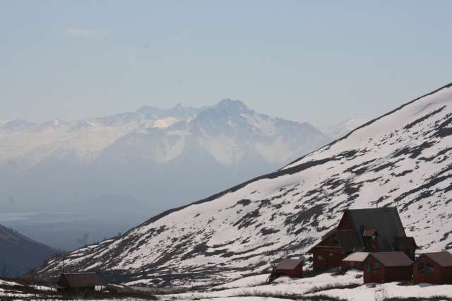 In the parking lot just above the Lodge, a view down into Mat-Su Valley. Weirdly enough, the view was clearer to the eye but the glacier dust in the air left many of my pix slightly hazy looking, even a couple I did with the tripod.
 Ol' manager's house up at the mine, now the gift shop.
 A closer look at some of the old mine buildings.
 Heading back down the pass. As you can tell, it hasn't green-ed up much but in a couple weeks that will change, I'm sure.
 I didn't stop on the way in but couldn't resist a quick stop on the way out at the viewing platform over the Little Su. How many hundreds of photos do I have of this almost identical view? Ha


Friday, May 21, 2010
Chirp, chirp, and Smile, you're on Candid Camera
 Not the greatest shot into the sun and through the living room window, but I'd say that while I've been bird watching, the birds are watching me back!
 "Smile, you're on camera. We monitor this lot." Windbreak/Trout House parking lot. I waved and smiled.
Sunday, May 16, 2010
Wasilla Wanderings
 Oh, yeah, moose butt!
 Do you think anyone would notice if some of us snuck over one night and corrected this sign, maybe adding at least "Close to..." to it?
 Found this one in the parking lot of the Windbreak/Trout House. Just looked weird to me, but also a fun photo.
Sunday, May 09, 2010
Palmer Sunday Scenics
 This first set of pix was taken from beside of or just past the bridge over the Matanuska River outside of Palmer.


 I'd moved over near the ol' bridge to look back and shoot this one across the road (Old Glenn, which goes on out to Butte and places beyond).
 The ol' bridge from the viewing/parking area just across the bridge.
 Moving on, decided to make a quick pit stop for pix at a pull-over off of Glenn just past where you'd turn onto Palmer-Fishhook to head toward Hatcher or, if you wanted to miss some traffic, Wasilla. This is the sign at the pull-over.
 Doesn't my car look tiny from my perch atop the viewing point?


Subscribe to:
Comments (Atom)